TerrSet is an integrated geospatial software system for monitoring and modeling the earth system for sustainable development. The TerrSet system incorporates the IDRISI GIS Analysis and IDRISI Image Processing tools along with a constellation of vertical applications. TerrSet offers the most extensive set of geospatial tools in the industry in a single, affordable package. There is no need to buy costly add-ons to extend your research capabilities.
Along with the software features mentioned below, TerrSet also includes utilities for import and export of all major file and imagery formats along with comprehensive documentation and tutorials.
TerrSet 2020 System Requirements
TerrSet 2020 Software Features

The IDRISI GIS tool set offers over 300 analytical tools, primarily oriented to raster data, for the manipulation of geospatial datasets for the exploration of our rapidly changing world.
The IDRISI Image Processing System in TerrSet is an extensive set of procedures for image restoration, enhancement, transformation and classification of remotely sensed imagery.
Land Change Modeler (LCM) is an innovative land planning and decision support software tool for land change analysis and prediction with a special facility for REDD project-level modeling.
Habitat and Biodiversity Modeler
The Habitat and Biodiversity Modeler (HBM) is a vertical application intended for habitat assessment, landscape pattern analysis and biodiversity modeling.
GeOSIRIS is a tool that quantifies and maps the impacts of national-level REDD projects on deforestation, carbon emissions, agricultural revenue, and carbon payments.
The Ecosystem Services Modeler (ESM) is a spatial decision support system for assessing the value of natural capital for sustainable development.
The Earth Trends Modeler (ETM) is an integrated suite of tools for the analysis of image time series data associated with Earth Observation remotely sensed imagery.
Climate Change Adaptation Modeler
The Climate Change Adaptation Modeler (CCAM) is suite of tools for modeling future climate and assessing its impacts on sea level rise, crop suitability and species distributions.
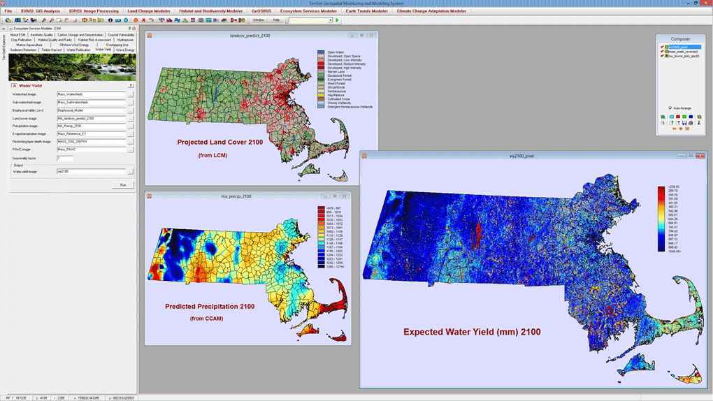
The Ecosystem Services Modeler (ESM) is closely based on the InVEST tools developed by the Natural Capital Project. Fifteen ecosystem service models have been implemented. In this illustration, ESM is used to evaluate water yield and water scarcity in the year 2100 for the state of Massachusetts. The predicted land cover input was generated by Land Change Modeler in TerrSet and the predicted precipitation was generated by the Climate Change Adaptation Modeler in TerrSet. The outputs from water yield are used to calculate hydropower potential at the subwatershed level in the year 2100.
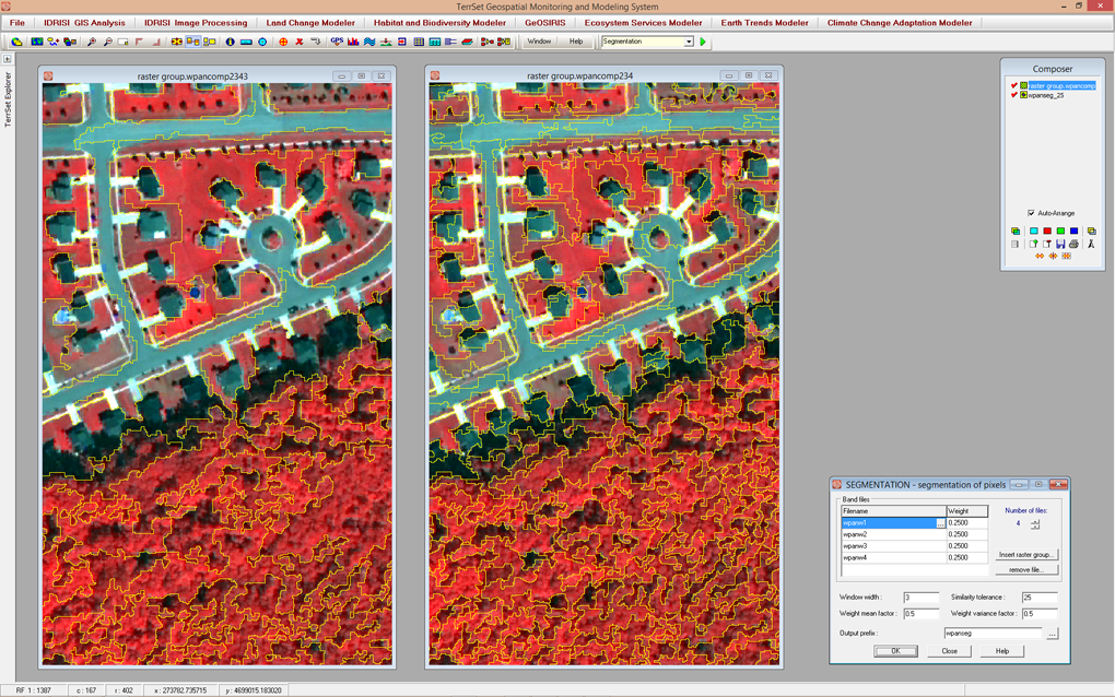
The SEGMENTATION module creates an image of segments that have spectral similarity across many input bands. This example shows two levels of segmentation from panmerged Quickbird imagery. The image on the left uses a larger similarity threshold than the one on the right, resulting in more generalized, less homogeneous segments. Altering this threshold allows for the segmentation of objects, such as forest stands, tree crowns or buildings.
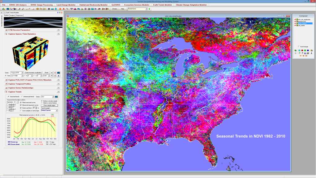
The Earth Trends Modeler (ETM) is specially designed for the analysis of earth observation image time series. In this illustration, a series of 348 global images of monthly NDVI vegetation index data were analyzed for the presence of trends in seasonality. Pixels colored gray (which are almost absent) indicate a stable seasonality. All other colors represent trends. ETM provides an interactive legend (lower left) to interpret the trend for any area (the area in eastern Alabama and western Georgia in this case). The green curve represents the beginning of the series (1982) while the red one represents the end (2010). The X axis is time and the Y axis is NDVI. As can be seen, NDVI has generally increased with a growing bimodality. Spring is coming a bit earlier (11 days) and the autumn is extending longer (almost 30 days).
TerrSet 2020 System Requirements
TerrSet is an object-oriented system designed for professional-level use on platforms employing the Microsoft Windows operating environment.
- Windows 8.1 and above, or Windows Server 2008 and above
- Microsoft ACE 2010 or Microsoft Office 2010 or later
- 1.3 GB hard drive space for application
- 7.5 GB hard drive space for tutorial data
- 8 GB RAM, 16 GB or more recommended
- HD display (1920×1080) or greater recommended