The IDRISI Image Processing System in TerrSet is comprised of an extensive set of procedures for image restoration, enhancement, transformation and classification of remotely sensed imagery. For over 30 years, Clark Labs has been involved in the development of geospatial technologies, supplying the community with the most comprehensive image processing system on the market. The tools available for classification offer the broadest procedures in the industry including both hard and soft classification procedures based on machine learning (such as neural networks) and statistical characterization. These tools are integrated within TerrSet and accompany the IDRISI GIS Analysis tools, saving effort, costs and resources.
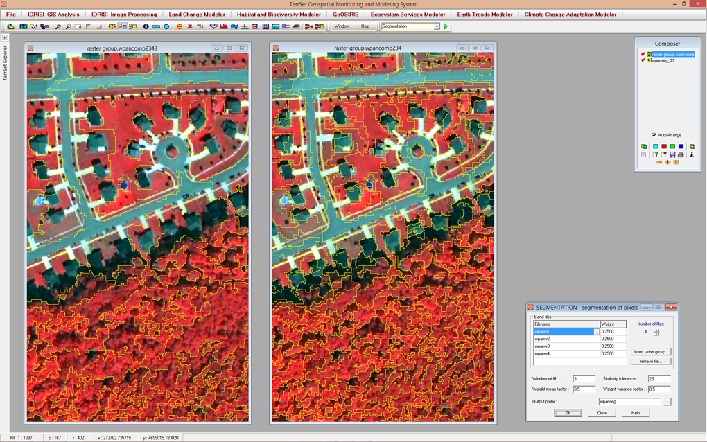
The SEGMENTATION module creates an image of segments that have spectral similarity across many input bands. This example shows two levels of segmentation from panmerged Quickbird imagery. The image on the left uses a larger similarity threshold than the one on the right, resulting in more generalized, less homogeneous segments. Altering this threshold allows for the segmentation of objects, such as forest stands, tree crowns or buildings.
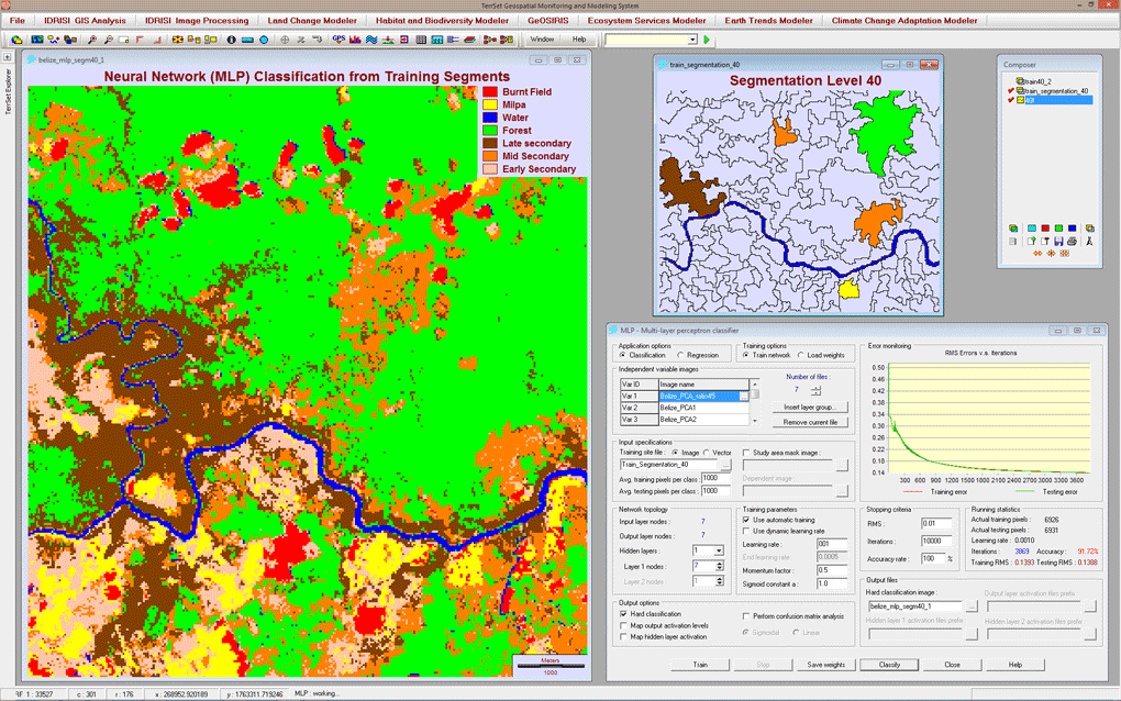
In this image, Segmentation was run from multi-spectral bands and then used to create training sites. The multi-layer perceptron neural network classifier in TerrSet was used to classify the image using the segmentation training data.
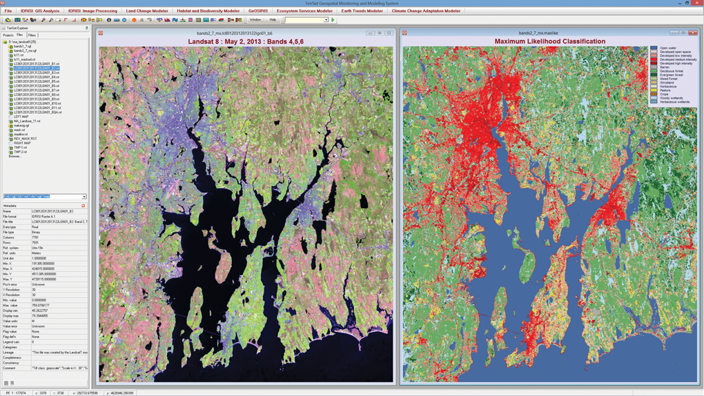
TerrSet includes the IDRISI image processing toolset with the most extensive set of classifiers for remotely sensed imagery in the industry. In this example, a Landsat 8 image of Rhode Island for May 2103 was classified using a Maximum Likelihood classifier and training data for classes consistent with the U.S. National Land Cover Database (NLCD).
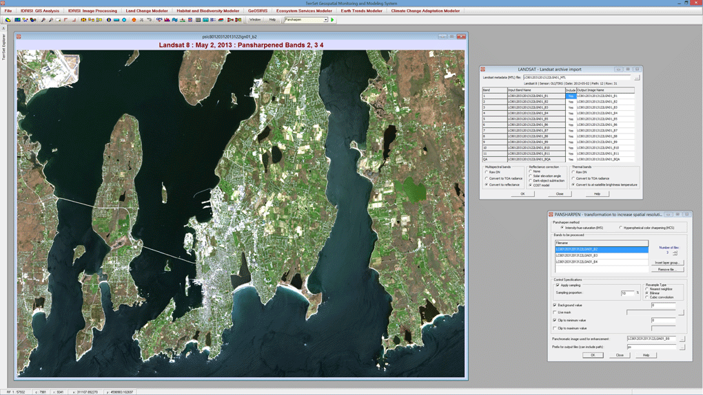
The TerrSet IDRISI Image Processing toolset includes an automated import and atmospheric correction utility for the archived Landsat data. A panchromatic band merge facility can dramatically increase the resolution of the original Landsat imagery.
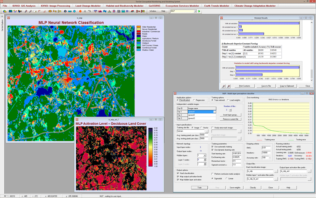
A variety of machine learning classifiers are available within TerrSet. Neural network classifiers include a multi-layer perceptron, self-organizing map, and fuzzy ARTMAP. Each allows complete control over all parameters.
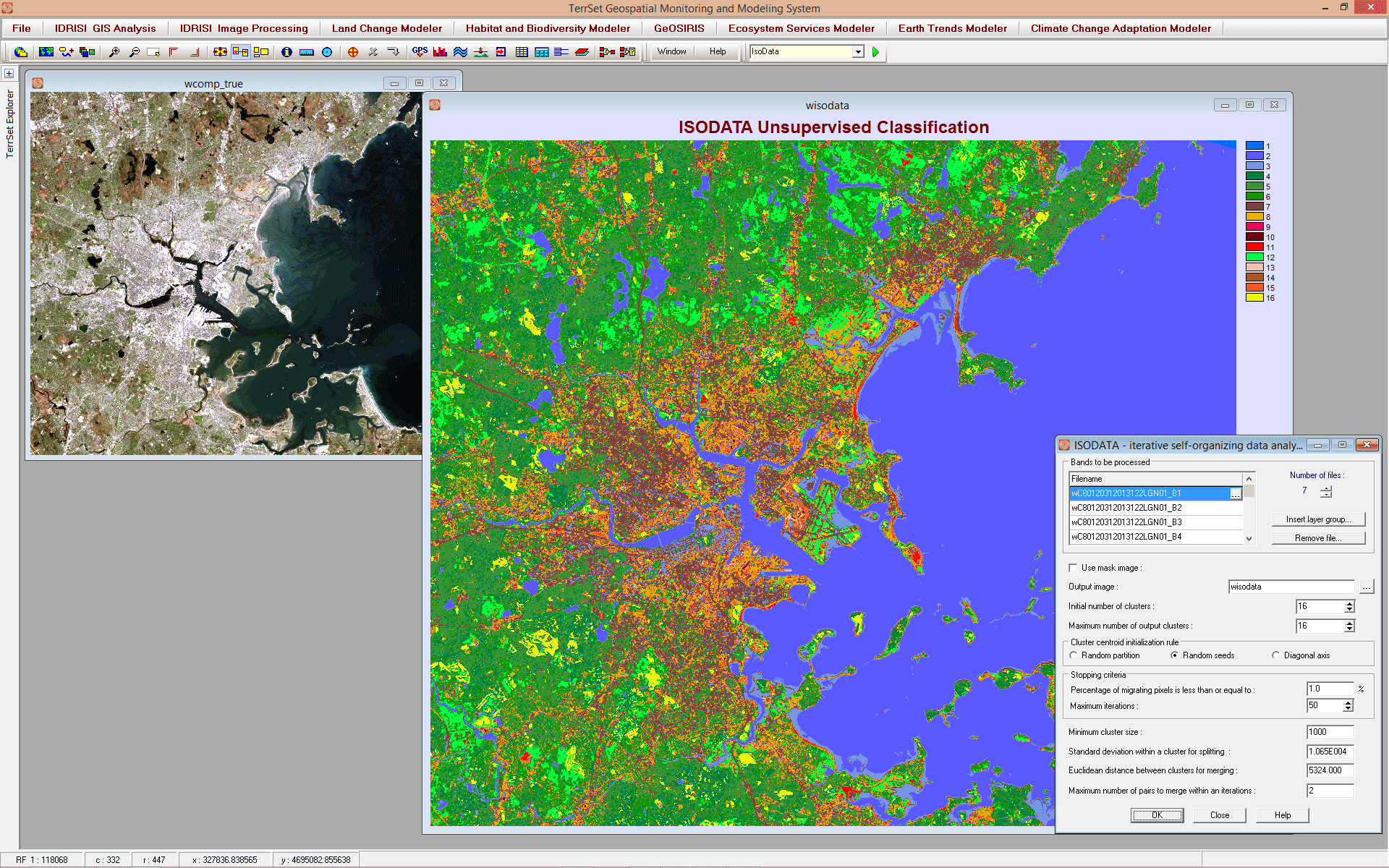
TerrSet provides a range of unsupervised classification tools including ISODATA. As illustrated here, the result of an unsupervised classification using the ISODATA tool on Landsat 8 imagery.
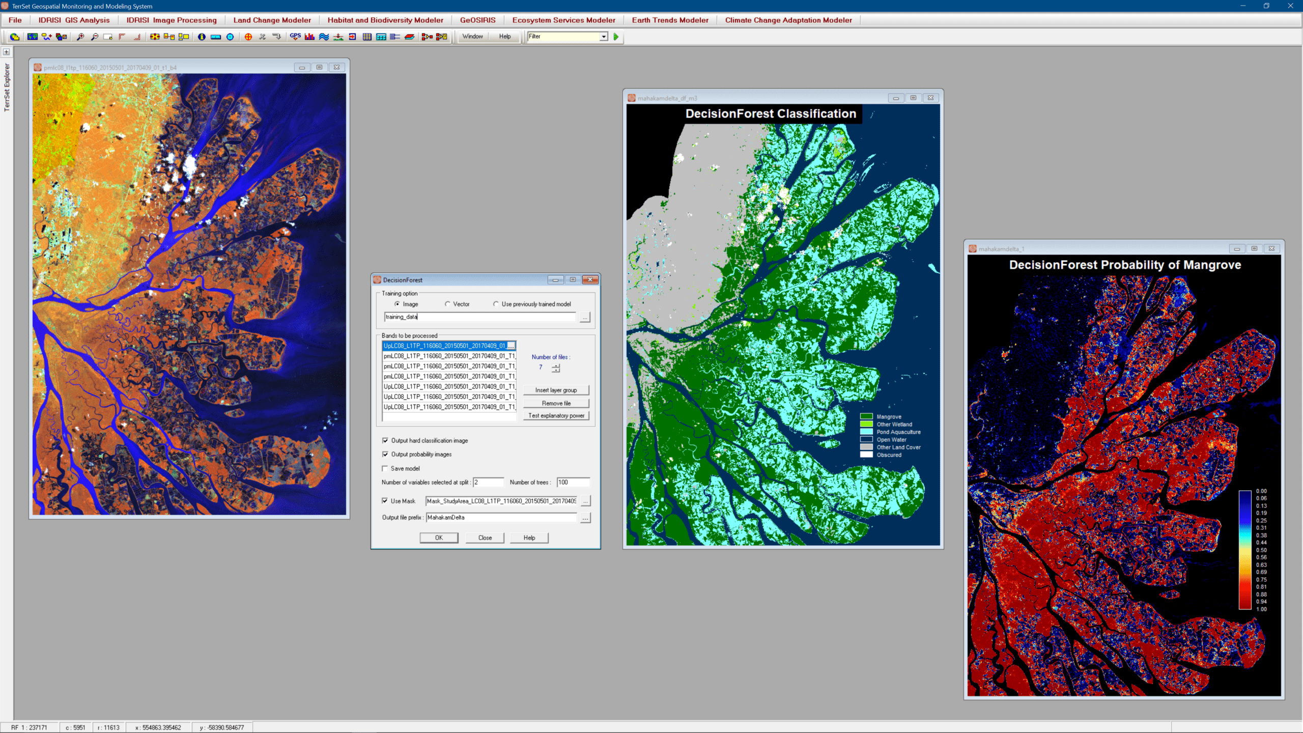
The IDRISI Image Processing component has seen extensive changes including new machine learning classifiers (SVM and DecisionForest), extensive on-screen digitizing tools, and specialized software for the ingest and radiometric correction of major provider imagery, such as Landsat, Sentinel, and DigitalGlobe (WorldView, QuickBird and GeoEye).
IDRISI Image Processing Key Features
Image Restoration
- A complete set of geometric and radiometric tools for correcting image registration and removing image distortion.
- Atmospheric correction using either the Dark Object Subtraction model, Chavez’s Cos(t) model, the full radiative transfer equation model, or the Apparent Reflectance Model (ARM). Fully automated for Landsat.
- Image mosaicking for color balancing multiple scenes into a single image.
- Radiance calibration to convert raw DN.
- Principal components analysis including standardized and unstandardized modes.
- An interactive image resampling facility.
Image Enhancement
- Tools for display image enhancement that highlight information within the image.
- Image filtering that includes 10 pre-defined filters and the ability to employ a variable sized user-defined filter.
- Panchromatic merge for image pansharpening of high resolution satellite imagery.
Image Transformation
- An extensive base-image transformation tool set.
- Principal components analysis, including standardized and unstandardized, cross-product and normalized cross-product modes.
- Canonical correlation analysis for between image series pattern analysis.
- Minimum noise fraction for variable image noise reduction.
- Vegetation index analysis with 19 slope-based and distance-based indices.
- Other indices include soil salinity, snow index and water index.
Image Classification
- The most extensive set of image classifiers in the industry, including hard and soft classifiers.
- Supervised classifiers that include parallelepiped, minimum distance, maximum likelihood, Fisher LDA, and k-nearest neighbor (KNN).
- Unsupervised classifiers that include ISODATA, chain cluster, and K-means.
- Machine-learning classifiers that include Classification Tree Analysis (CTA), Decision Forest (Random Forest implementation), Support Vector Machine (SVM) and 4 neural network classifiers: Multi-Layer Perceptron (MLP), Self-Organizing Map (SOM), Fuzzy ARTMAP, and Radial Basis Function.
- Soft classifiers and mixture analysis tools that include a Bayesian probability classifier, Mahalanobis distance classifier, fuzzy set classifier, and linear spectral unmixing. MLP, Decision Forest, SVM, KNN and SOM also produce soft classification outputs.
Image Segmentation
- Tools for image segmentation and object-oriented classification.
- A segmentation tool that produces segments based on spectral similarity.
- An interactive signature development tool to facilitate signatures from segments.
- A majority-rule classifier specifically built for segmentation classification.
Imagery Import Support
- Import support for all the popular data archive and provider formats.
- Automated import and radiometric correction of the Landsat archive.
- Automated import and radiometric correction of the Landsat, Senitnel 2, and the DigitalGlobe archives.
- Extended import support using GDAL.
Other Key Image Processing Features
- Hyperspectral image analysisA suite of tools for processing hyperspectral data, including classification routines, supervised and unsupervised. Classification routines include spectral angle mapper and continuum removal. and classification.
- Classification accuracy assessment.
- Land Change Modeler, an application for the monitoring and prediction of land cover change.
- Earth Trends Modeler, an application for the analysis of image time series.
- A seamless link to IDRISI GIS Analysis tools.